


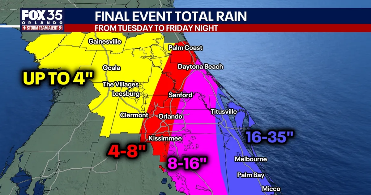
Central Florida is facing another round of torrential rain on Friday, with a high risk of flash flooding across coastal communities and weekly rainfall totals potentially reaching 35 inches in parts of Brevard County.
Brevard, eastern Osceola and southern Volusia counties are expected to bear the heaviest rainfall, with a further 8 to 16 inches possible in Brevard alone. Between 8 and 20 inches has already fallen there since Tuesday night, leaving the ground saturated and vulnerable to rapid flooding.
The most exposed areas include Titusville, Cocoa Beach, Satellite Beach and Melbourne Beach, where combined rainfall totals could reach between 18 and 35 inches. Melbourne is facing one of the highest projected totals, with some forecasts indicating up to 17 inches on Friday.
Metro Orlando lies within a sharp rainfall gradient. The area is expected to receive between four and 16 inches, with the heaviest conditions forecast for Thursday and Friday.
Central Florida flash flooding risk
A high risk of widespread flash flooding has been issued for Friday from Brevard County northwards through New Smyrna Beach and Daytona Beach. A moderate risk covers much of the eastern half of Central Florida, including Palm Coast, Sanford, Bithlo and St Cloud.
Showers are expected to become heavier shortly before sunrise and continue through Friday, with further rain possible into Saturday morning. Lingering winds are also forecast as a coastal low-pressure system develops near the Space Coast.
Forecast models differ on the system’s precise track. One scenario keeps the low offshore, concentrating the most intense rainfall near the coast, while another brings it closer inland and shifts extreme totals towards the Interstate 4 corridor.
Under the offshore scenario, rainfall could reach 17 inches in Melbourne, 9.9 inches in Cocoa Beach and 6.3 inches in Titusville. Totals would fall further inland, to about 4.7 inches in Bithlo and 2.2 inches in Orlando.
The alternative forecast gives New Smyrna Beach and Cocoa Beach up to 16 inches, Daytona Beach 14 inches, Titusville 13 inches, Bithlo 12 inches, DeLand 9.3 inches and Sanford 8.2 inches. Melbourne remains at a possible 17 inches under that scenario.
Rainfall totals by county
Flagler and Volusia counties have already received between six and 12 inches since Tuesday night. A further two to eight inches could bring overall totals to between eight and 16 inches, with isolated areas reaching 24 inches.
Projected totals range from seven to 14 inches in Palm Coast, 13 to 16 inches in Daytona Beach and 13 to 24 inches in New Smyrna Beach. DeLand could receive between 8.7 and 10 inches.
In Orange and Seminole counties, rainfall since Tuesday night has generally reached three to 10 inches, with isolated locations recording 17 inches. Another four to eight inches is possible in eastern areas and two to four inches in the west, producing weekly totals of 10 to 14 inches and isolated pockets of up to 24 inches.
Orlando is forecast to receive between 4.5 and 6.2 inches, while Sanford could see 8.2 to 9.1 inches. Bithlo faces between 10 and 14 inches.
Osceola and Polk counties have recorded two to six inches so far and could receive a further two to eight inches on Friday. Total rainfall is expected to reach eight to 12 inches, with Kissimmee forecast at 3.9 to 8 inches, St Cloud at 4.2 to 10 inches and Winter Haven at 1.6 to 4 inches.
Further west, the rainfall is expected to ease. Lake, Marion and Sumter counties have received between three and six inches since Tuesday night and could see up to another two inches, bringing overall totals to between four and seven inches.
Ocala could receive between 2.2 and 5.3 inches, while totals in The Villages and Leesburg range from about two to seven inches. Clermont is forecast to receive about five inches, with Bushnell facing between 2.1 and 3.8 inches.
St Johns River reaches record crest
The St Johns River recorded its highest crest on Thursday and is expected to continue rising to nearly 19 feet in the coming days.
River levels have climbed into the top five highest crests on record, with the flooding linked to a historic El Niño-fuelled winter weather system and compared with levels previously reached during hurricanes.
Residents across the affected areas have been warned to remain alert for localised flooding until the system begins to weaken over the weekend.
