


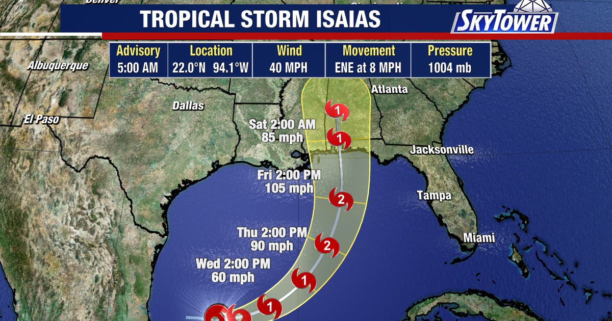
Tropical Storm Isaias has formed in the south-western Gulf of Mexico and is expected to strengthen into a hurricane before reaching the northern Gulf Coast later this week.
The storm developed early on Wednesday, 7 October, about 285 miles west of Progreso in Mexico, with maximum sustained winds of 40mph. It was moving east-north-east at around 8mph, according to the US National Hurricane Center. ([prod-west-nhc.woc.noaa.gov](https://prod-west-nhc.woc.noaa.gov/mobile/text/refresh/MIATCPAT4%2Bhtml/070852.shtml?utm_source=openai))
Forecasters expect Isaias to intensify rapidly over the next two days, with the National Hurricane Center saying it could become a hurricane by Thursday. No coastal watches or warnings were in force on Wednesday morning, although communities along the northern Gulf Coast were urged to monitor its progress. ([prod-west-nhc.woc.noaa.gov](https://prod-west-nhc.woc.noaa.gov/mobile/text/refresh/MIATCPAT4%2Bhtml/070852.shtml?utm_source=openai))
Isaias forecast to approach the Gulf Coast
The system is expected to turn northwards as it is steered by a trough to the west and high pressure to the east. Current forecasts suggest it could approach the coast late on Friday night or early on Saturday.
FOX 13 meteorologist Dave Osterberg said Isaias could become the first hurricane of the 2026 Atlantic season and may reach Category 2 or Category 3 strength.
Osterberg’s projected track takes the storm towards the coast just west of the Florida Panhandle, near Mobile Bay in Alabama. New Orleans and Panama City were not within the forecast cone in the latest assessment.
The National Weather Service has identified the developing system as the principal concern for the northern Gulf Coast in its longer-range forecast, with guidance pointing towards possible impacts in south-east Louisiana and southern Mississippi. ([marine.weather.gov](https://marine.weather.gov/product.php?format=CI&glossary=0&issuedby=LIX&product=AFD&site=HGX&version=2&utm_source=openai))
Storm surge and tornado threat
The eastern side of Isaias is expected to bring the greatest risk of storm surge, heavy weather and tornadoes as the system nears land.
Residents from the Florida Panhandle westwards to the Mississippi-Louisiana border have been advised to review their hurricane preparations and continue monitoring official forecasts. The storm’s exact track and final strength remain uncertain, particularly because wind shear could weaken it as it approaches the coast.
