


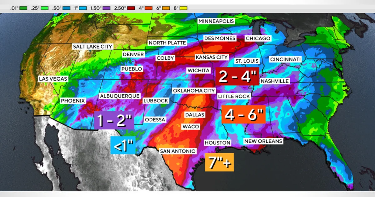
Tropical Storm Polo is bringing the threat of heavy rain and flash flooding across the south-western United States after crossing Mexico, with more than 30 million people potentially affected from Arizona to Iowa.
The storm was downgraded from a hurricane on Tuesday afternoon as it moved inland. Roads in southern New Mexico have already been flooded, leaving drivers trapped in vehicles until the water receded.
Polo made landfall in Mexico’s Baja California Sur as a hurricane before crossing the Gulf of California and making a second landfall in Sonora. It was travelling north-east at about 21mph and was expected to approach El Paso on Wednesday morning.
Maximum sustained winds were recorded at 65mph on Tuesday, with the storm centred about 275 miles south-west of El Paso. Winds were forecast to ease to roughly 35mph by the time it reached the city.
Flash flood watches across the US
Flash flood watches were in effect from Phoenix, Arizona, to Des Moines, Iowa. More than 14 million Americans faced the risk of major flooding, while some areas could receive up to two inches of rain an hour.
The National Weather Service Prediction Center warned of a “significant flash flood threat across the Four Corners Region eastward into the Central Plains”.
Albuquerque was a particular concern, with meteorologist Rob Marciano warning that rainfall could be “saturating”. The New Mexico city was forecast to receive about two inches of rain.
Rain was expected to continue into Wednesday across southern Colorado and parts of the Interstate 35 corridor. Areas of Texas, including Dallas, could see rainfall through Thursday, with some parts of the state forecast to receive more than seven inches.
Polo’s rapid intensification
Before weakening, Polo fluctuated between Category 4 and Category 5 hurricane strength. Its winds rose from 45mph to 150mph between September 21 and 22, a process known as extreme rapid intensification.
The storm’s maximum sustained winds reached 180mph over the weekend, tying the 2009 Hurricane Rick as the third-strongest recorded in the region. Its central pressure made it the second-strongest hurricane on record in the eastern Pacific, behind only Hurricane Patricia in 2015.
Warmer waters, moist air and reduced wind shear have helped support storm formation in the Pacific, while unusually strong El Niño conditions have contributed to increased tropical cyclone activity. Another major storm, Hurricane Nolo, passed near Hawaii’s Big Island over the weekend, bringing heavy rain and winds to the state.
