


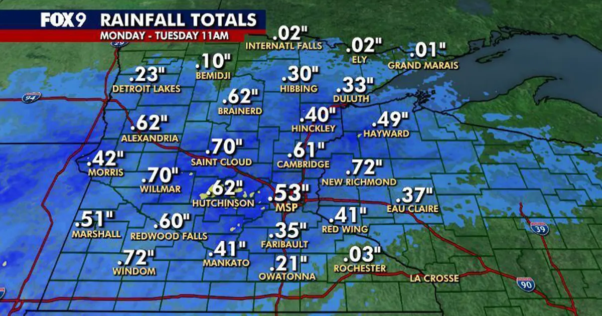
Rainfall across Minnesota topped half an inch in many areas after a wet start to the week, with parts of the Twin Cities metro recording close to an inch by late morning on Tuesday, October 27.
Showers were clearing towards the north-east on Tuesday, although patchy drizzle and light rain remained possible into the afternoon. Skies were expected to stay mostly cloudy as conditions gradually became drier.
Minnesota rain totals
The highest reported totals statewide included 0.72 inches at both New Richmond and Windom, followed by 0.70 inches at St Cloud and Willmar. Brainerd, Alexandria and Hutchinson each recorded 0.62 inches, while Cambridge saw 0.61 inches.
At Minneapolis-St Paul International Airport, rainfall reached 0.53 inches by 11am. Marshall recorded 0.51 inches, while totals were lower in parts of northern Minnesota, including 0.10 inches at Bemidji and just 0.01 inches at Grand Marais.
Other reported totals included 0.60 inches at Redwood Falls, 0.49 inches at Hayward, 0.42 inches at Morris, 0.41 inches at both Mankato and Red Wing, and 0.33 inches at Duluth.
Twin Cities metro sees almost an inch
Waconia recorded the highest total in the Twin Cities area, with 0.93 inches by 11am. Coon Rapids received 0.92 inches, while Scandia and Stillwater recorded 0.88 and 0.87 inches respectively.
Rainfall reached 0.85 inches in both Robbinsdale and Victoria, 0.83 inches in Blaine and 0.80 inches in Maple Plain. Minneapolis recorded 0.79 inches, while Minnetonka and Carver each saw 0.78 inches.
Totals elsewhere included 0.75 inches at both Hugo and Woodbury, 0.74 inches in Mound, Forest Lake, Roseville and Rosemount, and 0.65 inches in St Paul. Burnsville recorded 0.53 inches and Prior Lake 0.51 inches.
The National Weather Service in Twin Cities said the wider weather system had produced rainfall totals generally ranging from 0.50 to 1.00 inches across its forecast area.
Thunderstorms possible on Wednesday
Attention will now turn to Wednesday, October 28, when a cold front is expected to move across the region during the afternoon and evening. The National Weather Service said isolated to scattered thunderstorms could develop, with some storms potentially bringing small hail or gusty winds.
Temperatures are forecast to rise into the 60s across much of Minnesota on Wednesday, with lower 70s possible in southern parts of the state and western Wisconsin before cooler air arrives behind the front.
Further showers are possible from Friday into Halloween, with another chance of rain forecast for Monday.
