


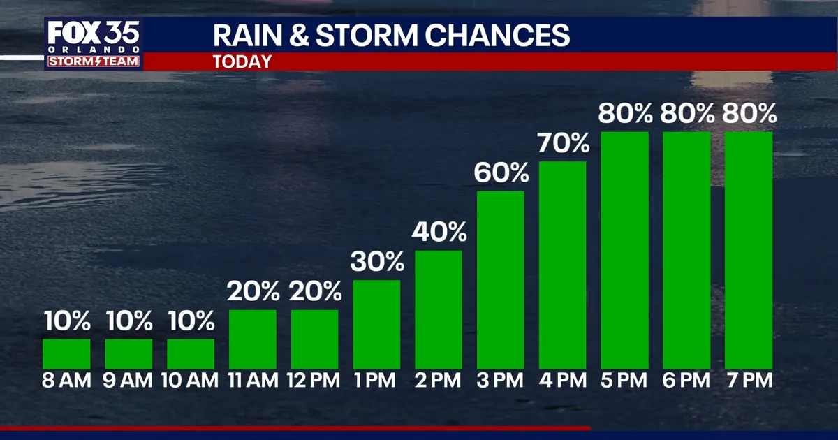
Central Florida is facing its wettest spell of the week, with showers and thunderstorms expected to become more widespread across Orlando on Tuesday and continue into the weekend.
Early mist, drizzle and isolated light showers are expected to give way to a brief lull before heavier rain develops after lunchtime. Forecasters say the greatest risk will come during the afternoon and evening, when rain could affect the commute and some storms may bring frequent lightning, gusty winds and torrential downpours. ([fox35orlando.com](https://www.fox35orlando.com/news/orlando-weather-rainy-week-ahead-central-florida.amp))
The unsettled conditions are being driven by a stalled frontal boundary over Florida, alongside an area of low pressure near the state’s east coast. That pattern is expected to keep moisture in place and produce repeated rounds of rain rather than a single, fast-moving storm system. ([fox35orlando.com](https://www.fox35orlando.com/news/orlando-weather-rainy-week-ahead-central-florida.amp))
Heavy rain and localised flooding risk
Rain chances are expected to reach about 80 per cent on Tuesday and remain high through much of the week. While there should be occasional breaks, the heaviest activity is forecast during the afternoon, with scattered to widespread rain possible across Central Florida.
Some storms could produce wind gusts of 35 to 45mph, while slow-moving cells may release several inches of rain in a short period. Officials are warning of flooding on roads and in low-lying or poorly drained areas, particularly where downpours repeatedly pass over the same locations. ([fox35orlando.com](https://www.fox35orlando.com/news/orlando-weather-rainy-week-ahead-central-florida.amp))
Overall rainfall totals of roughly 3 to 5 inches are expected across the region, with isolated locations potentially receiving 6 inches or more. The unusually wet pattern is not expected to ease substantially until this weekend or the beginning of next week.
Above-average rain chances will continue from Thursday through Sunday, although the forecast is not for constant rain all day. Showers and storms are likely to arrive in waves, with some mornings quieter before activity increases later in the day. ([fox35orlando.com](https://www.fox35orlando.com/news/orlando-weather-rainy-week-ahead-central-florida.amp))
Invest 92L monitored in the Gulf
The National Hurricane Center is also tracking Invest 92L, a trough of low pressure producing disorganised showers and thunderstorms in the south-western Gulf of America.
The system had an 80 per cent chance of developing into a tropical depression within 48 hours and over the following seven days as of Tuesday morning. Forecasters expect it to move east-north-east before turning north, but said it was too early to determine specific impacts along the northern Gulf Coast. ([nhc.noaa.gov](https://www.nhc.noaa.gov/text/refresh/MIATWOAT%2Bshtml/151140_MIATWOAT.shtml?utm_source=openai))
For Orlando and the surrounding parts of Central Florida, the immediate threat remains the prolonged period of heavy rain linked to the stalled front and nearby low pressure, rather than the developing Gulf disturbance itself.
