


Minnesota faces a sharp turn towards autumn on Friday, October 16, with morning showers, strong northerly winds and afternoon sunshine followed by widespread frost and freezing temperatures overnight.
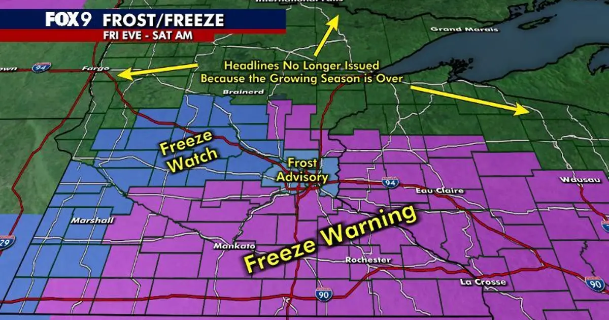
The National Weather Service has issued a frost advisory for the Twin Cities metropolitan area, while freeze warnings cover parts of central and southern Minnesota and western Wisconsin. A freeze watch remains in place for several counties where sub-zero Celsius temperatures are possible.
Minnesota weather forecast brings blustery conditions
Friday will begin cold and unsettled, with lingering showers and cloud gradually clearing from the north and west. The Twin Cities is expected to reach about 50F (10C), while temperatures elsewhere remain in the upper 40s and low 50s Fahrenheit.
Northerly winds of 15 to 25mph, with stronger gusts in places, will make conditions feel considerably colder. The wind is forecast to ease during the late afternoon and evening as skies clear.
Temperatures will fall rapidly overnight under clear and calmer conditions. The mercury is expected to drop to the mid-30s Fahrenheit in the Twin Cities, with upper-30s readings in parts of western Minnesota.
In areas covered by the freeze warning, temperatures could fall into the upper 20s and low 30s Fahrenheit between 1am and 9am on Saturday, October 17. The warning includes parts of central, east-central, south-central, south-western and south-eastern Minnesota, as well as neighbouring areas of Wisconsin. ([forecast.weather.gov](https://forecast.weather.gov/showsigwx.php?firewxzone=MNZ044&lat=45.5706&local_place1=Princeton+MN&lon=-93.5908&product1=Red+Flag+Warning&warncounty=MNC095&warnzone=MNZ044&utm_source=openai))
The frost advisory for Hennepin, Anoka, Ramsey and Washington counties is in force from 1am to 8am on Saturday, with temperatures as low as 34F (1C) expected. The National Weather Service warned that exposed plants and other sensitive vegetation could be damaged. ([forecast.weather.gov](https://forecast.weather.gov/showsigwx.php?firewxzone=MNZ062&lat=45.0847&local_place1=White+Bear+Lake+MN&lon=-93.0099&product1=Frost+Advisory&warncounty=MNC123&warnzone=MNZ062&utm_source=openai))
Forecasters are also warning that freezing conditions could harm crops and unprotected outdoor plumbing in the colder parts of the region. The weather service said widespread frost or a freeze was expected across central and southern Minnesota overnight. ([forecast.weather.gov](https://forecast.weather.gov/showsigwx.php?firewxzone=MNZ062&local_place1=Saint+Paul+MN&product1=Frost+Advisory&warncounty=MNC123&warnzone=MNZ062&utm_source=openai))
Conditions will improve markedly on Saturday, when sunshine is expected to return and temperatures climb into the low 60s Fahrenheit, although breezy conditions will persist.
Sunday is forecast to be brighter and milder, with lighter winds and highs in the mid-60s. The warming trend is expected to continue next week, with temperatures reaching the upper 60s and low 70s under generally sunny skies.
