


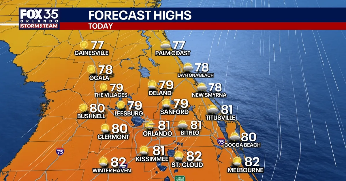
Orlando weather is expected to remain sunny and comfortable through the working week, with cool mornings giving way to afternoon temperatures in the upper 70s and low 80s across Central Florida.
Morning lows will fall into the 50s and 60s, bringing a crisp, autumn-like start to the day before temperatures rise steadily by the afternoon. Rain-free conditions are forecast to continue through at least Friday.
Showers are expected to become more likely over the weekend, although the outlook remains generally warm, with daytime highs close to 80F.
Dangerous surf along Florida’s east coast
The pleasant conditions inland are being accompanied by hazardous weather along the Atlantic beaches. A high surf advisory remains in effect until early Wednesday, with waves of up to 10 feet forecast in parts of the coast.
The National Weather Service has also warned of a high risk of life-threatening rip currents, particularly around beaches in Volusia, Brevard, Indian River, St Lucie and Martin counties. Beachgoers have been urged to stay out of the water while the advisory is in force. ([forecast.weather.gov](https://forecast.weather.gov/product.php?format=TXT&glossary=0&issuedby=MLB&product=SRF&site=NWS&version=1&utm_source=openai))
North-easterly winds are contributing to the rough surf, with gusts expected to strengthen along the coast later in the week. The National Weather Service’s local forecast shows showers becoming more likely by Saturday and Sunday, alongside breezier conditions. ([forecast.weather.gov](https://forecast.weather.gov/MapClick.php?lat=28.07168&lon=-80.65339&utm_source=openai))
Tropical system monitored offshore
The National Hurricane Center is monitoring a storm-force, non-tropical low several hundred miles off the south-eastern US coast. The system could develop some subtropical characteristics while it remains over the Gulf Stream, before moving north-eastwards into the open Atlantic.
The centre has put the chance of development at 20% over the next 48 hours and 40% over the next seven days. It is not currently expected to bring direct tropical impacts to Florida, although its wider circulation is helping to produce strong winds, coastal flooding and dangerous surf along parts of the East Coast. ([nhc.noaa.gov](https://www.nhc.noaa.gov/text/refresh/MIATWOAT%2Bshtml/302309_MIATWOAT.shtml?utm_source=openai))
For Orlando and much of Central Florida, the immediate forecast remains considerably calmer: sunshine, mild afternoons and dry conditions are expected to dominate before scattered showers return over the weekend.
