


Heavy rain is sweeping across Minnesota on Monday, November 2, with the Twin Cities and northern parts of the state facing several days of wet weather and unusually mild temperatures.
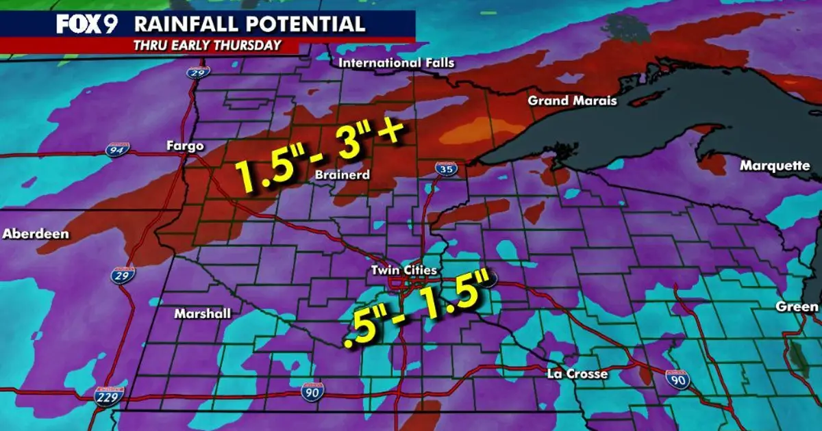
The National Weather Service said widespread rain would continue from Monday through Wednesday, with between 0.75in and 2in expected across much of the region and totals approaching 3in in parts of central Minnesota. ([forecast.weather.gov](https://forecast.weather.gov/product.php?format=txt&glossary=0&issuedby=MPX&product=AFD&site=GJT&version=1&utm_source=openai))
Heavy rain forecast for Minnesota
Drizzle and mist early in the day are expected to give way to steadier rain, with moderate downpours possible around Minneapolis and St Paul. The heaviest falls are forecast further north and west.
Rain should begin to ease during the evening commute, although showers are likely to continue overnight. The Twin Cities could receive between 0.5in and 1.5in by early Thursday, while the North Shore and parts of northern and western Minnesota could see 1.5in to more than 3in.
The rainfall comes after a notably mild start to November. Temperatures in central and southern Minnesota are expected to reach the low to mid-60s Fahrenheit, around 18C, while the Twin Cities could reach about 64F (18C), well above the usual early-November high of 49F (9C).
Forecasters said the slow-moving system contains an unusually high amount of moisture for November. The expected rainfall may bring useful relief to parts of Minnesota affected by drought, although the heaviest downpours could lead to difficult driving conditions and localised waterlogging. ([forecast.weather.gov](https://forecast.weather.gov/product.php?format=CI&glossary=0&issuedby=MPX&product=AFD&site=JKL&version=16&utm_source=openai))
Showers expected to continue through Wednesday
Tuesday is expected to remain grey and damp, with rain coming and going across the state and occasional longer breaks. Highs will stay in the 60s in some areas before cooler air moves in.
Further showers are forecast on Wednesday as temperatures fall towards the low 50s. The rain should gradually shift south and east during the evening, allowing conditions to turn drier on Thursday.
Temperatures are expected to remain in the low 50s on Friday and Saturday, with another chance of showers developing early in the weekend. The wider outlook suggests a return to more typical autumn conditions after the brief spell of summer-like warmth. ([forecast.weather.gov](https://forecast.weather.gov/product.php?format=txt&glossary=0&issuedby=MPX&product=AFD&site=GJT&version=1&utm_source=openai))
