


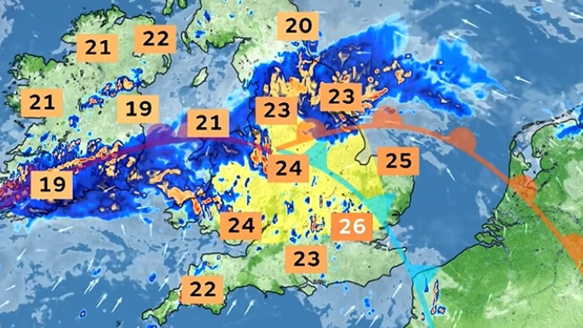
Britain faces ‘intense’ thunderstorms today and tomorrow as a month’s worth of rain falls on parched ground amid concerns ‘severe’ flash flooding could cut off villages.
The Met Office extended yellow warnings across England and Wales as a band of slow-moving heavy showers and thunderstorms travelled northwards this morning.
The first thunderstorm alert from 3am to 10pm today covers much of England including the South East, Midlands and North as well as northern and eastern Wales.
Forecasters said accumulations of up to 30mm (1.2in) of rain in less than an hour are expected today, while up to 50mm (2in) could fall over two to three hours.
The second thunderstorm warning from 6am to 10pm tomorrow will cover the whole of Wales as well a similar area of England, excluding London and the South West.
Accumulations of up to 30mm of rain in three hours can be expected fairly widely tomorrow and up to 50mm in a 12-hour period is anticipated in places.
East-facing high ground could see over 50mm in three hours tomorrow and more than 75mm (3in) through 12 hours. Hail of up to 2cm (0.8in) will also be a hazard.
The Met Office amended the area of the two warnings this morning, with today’s alert extended further north-westwards while removing it from parts of East Anglia.
Two women shelter from the pouring rain under an umbrella in Westminster last Thursday


Tomorrow’s warning was also extended further north-westwards by meterologists and will cover all of Wales while being removed from parts of eastern England.
Met Office chief forecaster Steve Willington said: ‘As we move into Wednesday there is a growing risk of heavy rain and thunderstorms, with warm and humid air helping to trigger heavy showers and thunderstorms.
‘Some places could see significant amounts of rain falling in a short period of time, bringing the potential for localised flooding, travel disruption and frequent lightning.
‘On Thursday, slow-moving heavy and thundery rain may bring prolonged rainfall to some areas, increasing the risk of localised impacts.
‘There remains some uncertainty around where the heaviest rain will fall, so it is important to keep up to date with the latest forecast and warnings.’
It follows hot weather in the UK which coincided with extremely dry conditions, with drought being declared in nearly three-quarters of England and the whole of Wales.
The RAC said risks to drivers from slippery roads from rainfall are ‘much greater right now as a result of the prolonged dry spell’.
It added that oil, fuel and rubber deposits that have built up will now have been mixed together by light rain, instead of being washed away, which means drivers are at greater risk of skidding on greasy roads.
London Mayor Sir Sadiq Khan said on X: ‘From 3am, London is at risk of severe flash floods. Intense downpours could see up to 50mm of rainfall arrive in the space of just a few hours – almost the total average rainfall for August.
‘Don’t be caught out – check your insurance covers flooding and see what more you can do to prepare.’ He then shared a link to his website on how to prepare for flash flooding.
The Met Office said the rain and thunderstorms this afternoon ‘may be intense’ – adding that there was a ‘small risk of flooding and disruption’, including possible damage to some buildings from floodwater, lightning strikes or hail.

The first thunderstorm warning runs from 3am to 10pm today for up to 50mm (2in) of rain

The second thunderstorm warning runs from 6am to 10pm tomorrow for up to 75mm of rain
It added that spray and sudden flooding could lead to difficult driving conditions and some road closures.
Large hail and frequent lightning are also possible before showers and thunderstorms drift northwards and ease during this evening.
In tomorrow’s warning, forecasters said there was a ‘small chance of fast-flowing or deep floodwater causing danger to life’.
They added: ‘Some communities might become cut off if roads flood.’
The Met Office has advised people to ‘ensure moveable objects or temporary structures are well secured’ before gusty winds arrive, including bins, garden furniture, trampolines, tents, gazebos, sheds and fences.
Unsettled conditions may continue into Friday and the weekend, with further showers or longer spells of rain possible at times, alongside some drier and brighter periods.
RAC road safety spokesman Rod Dennis said: ‘While slippery roads from rainfall is nothing new, the risks to drivers are much greater right now as a result of the prolonged dry spell.
‘Oil, fuel and rubber deposits that have built up over many weeks will now have been mixed together by the light rain, instead of being washed away, which means drivers are at greater risk of skidding on greasy roads.
‘If heavier rain arrives, motorists may have to contend with the danger of flash floods in some areas.
‘For this reason, we urge drivers to reduce their speed in rainfall of any intensity and leave extra space behind the vehicle in front to reduce the chance of avoidable collisions.’
The AA also urged drivers to prepare for rapidly changing road conditions.
Lee Morley, AA expert patrol, said: ‘After such a prolonged spell of hot and dry weather, drivers may not be expecting roads to suddenly become covered in surface water or even flooded, so they need to be ready to adapt quickly.
‘Slow down, increase the distance between you and the vehicle ahead and avoid sudden braking or sharp steering. Keep looking well ahead for surface water and be particularly cautious where water is beginning to collect.
‘Heavy rain and spray can also seriously reduce visibility, so make sure your lights, wipers and demisters are being used when needed.’
The UK is now in the final week of an exceptionally hot and dry summer which has plunged 71 per cent of England and all of Wales into drought, with 28million people under hosepipe bans.
Rivers and reservoirs are running low after some areas went two months without rain. Wisley in Surrey had 62 consecutive dry days until last week, while London Heathrow had 56 dry days.
Last month was the driest July on record for England, with the south-east left severely parched. Met Office data showed East Anglia had just 2mm (0.1in) of rainfall in July, and 56.3mm (2.2in) in June.
That means the 50mm of rain forecast for tomorrow is nearly as much as has been observed across the past two months combined.
The Environment Agency said last Friday that south-east England had received just 3mm of rain so far in August – with rainfall totals for the month still below average across all regions of England, despite wetter weather in some areas.
The average rainfall for south-east England in August – using the Heathrow weather station as an example – is 53mm (2.1in).
The Environment Agency added that seven reservoirs in England are now classed as having ‘exceptionally low’ storage levels, up from five a week ago.
The Met Office has previously said the UK is on course for its hottest summer on record after five major heatwaves swept the country with temperatures of up to 38.1C recorded in London.
Forecasters have also warned Britain faces more storms and rain this autumn and winter caused by an ‘unprecedented’ El Niño event.
El Niño is declared when sea temperatures in the tropical eastern Pacific rise 0.5C above the long-term average, impacting global rainfall patterns and temperatures.
The natural warming of sea temperatures is forecast to reach more than 3C in the coming months, according to Met Office calculations – while other climate groups have projected something even stronger, perhaps even 4C above average.
The Met Office said this year’s event will be ‘the largest since the 19th century’ – with one expert even claiming it could be the strongest ‘in 500 or even 1,000 years’.
