


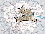
A new map of London’s most desirable neighbourhoods has reignited the debate over where to live in the capital, challenging the idea that the city’s finest addresses are concentrated around Notting Hill, Chelsea and Maida Vale.
The map, dubbed the “London squirrel” because of its outline, shifts attention towards parts of south and east London, including Peckham and Stratford. Its appearance has prompted renewed discussion about whether traditional assumptions about the capital’s best areas still reflect how Londoners live today.
It follows the popularity of the so-called “London banana”, a map which began circulating online in 2025. That map traced a crescent of affluent neighbourhoods from south-west London through Chelsea, Kensington and Notting Hill before sweeping north towards Hampstead, Highgate and Barnet.
The original map was drawn by property commentator Saul Sadka, who described the area as a concentration of attractive streets, good transport links, highly regarded schools and cultural amenities. It quickly divided opinion, with some Londoners praising its broad assessment of desirable districts and others accusing it of overlooking large parts of the capital.
The London squirrel map challenges the traditional view
The new version offers a more eastward and southward interpretation of London’s most appealing places. Peckham, known for its independent shops, restaurants and creative scene, is among the areas brought into the discussion, while Stratford benefits from its extensive transport connections, shopping facilities and proximity to the Queen Elizabeth Olympic Park.
Both districts have changed substantially in recent years, although they remain markedly different from the grand garden squares and Victorian terraces associated with prime west London. Their inclusion reflects the growing importance many residents place on nightlife, green space, cultural life and access to transport, rather than prestige alone.
The debate has also highlighted the limitations of trying to divide a city as varied as London into a single shape. Neighbourhoods can change considerably from one street to the next, while factors such as housing costs, schools, commuting times and crime levels can produce very different experiences within the same district.
Even the “London banana” was presented as a personal assessment rather than an official ranking. Its creator acknowledged that the boundaries were drawn from his own experience, although he argued that they broadly reflected wider indicators including property prices and crime levels.
The latest map is unlikely to settle the argument over the best places to live in London. Instead, it has provided a fresh reminder that the capital’s most sought-after neighbourhoods are no longer defined solely by its established west and north London enclaves.
